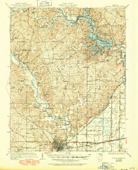
1935 Map of Poplar Bluff
USGS Topo · Published 1950About this map
The Black River dominates the western half of this landscape, its winding course defining the settlement patterns and infrastructure of Butler County. To the north, the Wappapello Reservoir appears during a period of significant hydraulic change, with its waters drowning portions of the river valley. The region is marked by a dense network of early rural institutions, including dozens of country schools such as Rucker School and Allison School, alongside landmarks like Collins Store and the Manso Bridge.
Find a feature on this map
85 named features on this map. Tap any name to fly to it.
Don’t see what you’re looking for? This feature index may not catch every label — zoom into the map to look around manually.
Map Details
Editions of this 1935 Poplar Bluff Map
3 editions found
Other maps of this area

1932 · Piedmont
USGS Topo · 1:62,500

1934 · Greenville
USGS Topo · 1:62,500

1934 · Williamsville
USGS Topo · 1:48,000

1934 · Puxico
USGS Topo · 1:62,500

1935 · Poplar Bluff
USGS Topo · 1:62,500

1935 · Zalma
USGS Topo · 1:62,500

1935 · Piedmont
USGS Topo · 1:62,500

1935 · Acorn
USGS Topo · 1:62,500

1935 · Harviell
USGS Topo · 1:62,500

1939 · Greenville
USGS Topo · 1:62,500