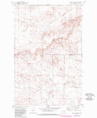
1973 Map of Poplar Coulee
USGS Topo · Published 1989About this map
The Fort Peck Indian Reservation covers the entirety of this landscape, where the high plains of Northeast Montana are deeply incised by a network of drainage channels. The terrain is defined by the winding course of Shipstead Coulee in the north and the namesake Poplar Coulee further south, illustrating the erosion patterns characteristic of this part of the Missouri River watershed. A singular Drill Hole in the northeast quadrant suggests early subsurface exploration in an area otherwise dominated by open rangeland and intermittent water sources. The map highlights the intersection of three counties, showing where Daniels, Valley, and Roosevelt counties meet. Numerous locations marked as Spring and Springs indicate the vital importance of surface water for livestock and settlement in this semi-arid environment, while Cottonwood Creek provides further evidence of the localized riparian corridors that break the upland expanse.
Find a feature on this map
10 named features on this map. Tap any name to fly to it.
Don’t see what you’re looking for? This feature index may not catch every label — zoom into the map to look around manually.
Map Details
Editions of this 1973 Poplar Coulee Map
2 editions found
Other maps of this area

1910 · Todd Lakes
USGS Topo · 1:62,500

1915 · Tule Valley
USGS Topo · 1:62,500

1915 · Todd Lakes
USGS Topo · 1:62,500

1954 · Wolf Point
USGS Topo · 1:250,000

1958 · Wolf Point
USGS Topo · 1:250,000

1973 · West Fork NE
USGS Topo · 1:24,000

1973 · Haugens Hill
USGS Topo · 1:24,000

1973 · Peerless 4 SW
USGS Topo · 1:24,000

1973 · Poplar Coulee
USGS Topo · 1:24,000
1973 · West Fork
USGS Topo · 1:24,000