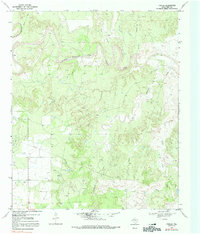
1969 Map of Poplar
USGS Topo · Published 1991About this map
The Double Mountain Fork Brazos River carves a deep, winding path through this West Texas landscape, defining the topography of Kent and Scurry Counties. During the late 1960s, the small settlement of Polar served as the primary hub for this ranching and oil-producing region, situated near the Polar Cem and the extensive Connell Ranch. The map reveals a land utilized for its natural resources, with numerous Oil Wells and a significant Pipeline network crossing the varied terrain. Smaller drainage features like Schoolhouse Hollow, Joe Smith Draw, and Shin Hollow feed into the river valley, while larger tributaries such as McKenzie Creek and Cooper Creek provide structure to the surrounding plains. This era captures the area's rural character, where local landmarks and industry, such as Gravel Pits and isolated drill sites, are the primary indicators of human presence.
Find a feature on this map
16 named features on this map. Tap any name to fly to it.
Don’t see what you’re looking for? This feature index may not catch every label — zoom into the map to look around manually.
Map Details
Editions of this 1969 Poplar Map
3 editions found
Other maps of this area

1954 · Lubbock
USGS Topo · 1:250,000

1954 · Big Spring
USGS Topo · 1:250,000

1958 · Big Spring
USGS Topo · 1:250,000

1969 · Cottonwood Creek
USGS Topo · 1:24,000

1969 · Justiceburg SE
USGS Topo · 1:24,000

1969 · Maverick Creek
USGS Topo · 1:24,000

1969 · Cooper Mountain
USGS Topo · 1:24,000

1969 · Clairemont West
USGS Topo · 1:24,000

1969 · T-O Creek
USGS Topo · 1:24,000

1969 · Flat Top Mountain
USGS Topo · 1:24,000