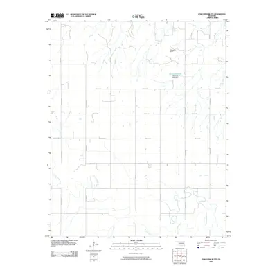
2009 Map of Porcupine Butte
USGS Topo · Published 2009About this map
The North Canadian River meanders across the southern portion of this landscape, its serpentine channel creating a stark contrast to the rigid section-line road grid that defines the Oklahoma interior. North of the river’s floodplain, the terrain rises toward Porcupine Butte, a distinct elevation that overlooks a patchwork of agricultural lands and rural homesteads. This early 21st-century survey illustrates the organized expansion of rural infrastructure, where named thoroughfares like N Walbaum Rd and N Red Rat Rd provide access to the interior sections. Water management is evident through features such as Oknoname 9 Lake, held by the Oknoname 017009 Dam. The road network, including major routes like Edmond Rd NW, shows the transition from simple section tracks to a more developed rural grid system supporting the modern ranching and farming operations in Canadian County.
Find a feature on this map
26 named features on this map. Tap any name to fly to it.
Don’t see what you’re looking for? This feature index may not catch every label — zoom into the map to look around manually.
Map Details
Editions of this 2009 Porcupine Butte Map
This is the sole edition of this map. No revisions or reprints were ever made.
Other maps of this area

1893 · Fort Reno
USGS Topo · 1:62,500

1893 · Loyal
USGS Topo · 1:62,500

1941 · Fort Reno
USGS Topo · 1:62,500

1942 · Fort Reno
USGS Topo · 1:62,500

1942 · Geary
USGS Topo · 1:62,500

1949 · Fort Reno
USGS Topo · 1:62,500

1955 · Clinton
USGS Topo · 1:250,000

1957 · Clinton
USGS Topo · 1:250,000

1967 · Fort Reno SW
USGS Topo · 1:24,000
1972 · Loyal SE
USGS Topo · 1:24,000