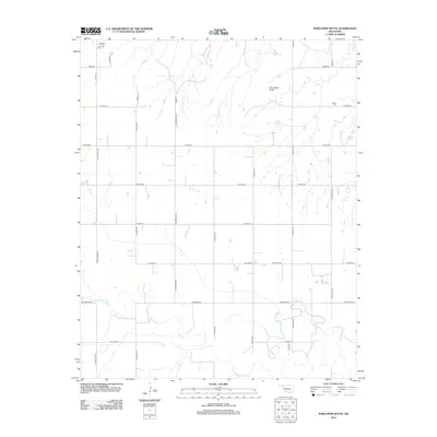
2012 Map of Porcupine Butte
USGS Topo · Published 2012About this map
North Canadian River meanders through the southern half of this Oklahoma landscape, defining a complex network of wetlands and shifting channels. To the north, the terrain is anchored by the prominent Porcupine Butte, a distinct landmark in an otherwise largely agricultural area. The map reveals a highly structured section-line road system, including thoroughfares like N Walbaum Rd and N Mayberry Rd, which segment the territory into regular plots.
Find a feature on this map
26 named features on this map. Tap any name to fly to it.
Don’t see what you’re looking for? This feature index may not catch every label — zoom into the map to look around manually.
Map Details
Editions of this 2012 Porcupine Butte Map
This is the sole edition of this map. No revisions or reprints were ever made.
Other maps of this area

1893 · Fort Reno
USGS Topo · 1:62,500

1893 · Loyal
USGS Topo · 1:62,500

1941 · Fort Reno
USGS Topo · 1:62,500

1942 · Fort Reno
USGS Topo · 1:62,500

1942 · Geary
USGS Topo · 1:62,500

1949 · Fort Reno
USGS Topo · 1:62,500

1955 · Clinton
USGS Topo · 1:250,000

1957 · Clinton
USGS Topo · 1:250,000

1967 · Fort Reno SW
USGS Topo · 1:24,000
1972 · Loyal SE
USGS Topo · 1:24,000