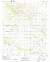
1979 Map of Porcupine Butte
USGS Topo · Published 1979About this map
The North Canadian River meanders across this landscape in the late 1970s, defining a broad valley floor where agriculture and industry meet. This region, spanning the borders of Blaine, Kingfisher, and Canadian counties, is dotted with evidence of Oklahoman resource extraction, from numerous Gas Wells and Oil Wells to the specialized Gypsum Pits near Porcupine Butte. Local community life is anchored by landmarks such as the Swappingback Mission, the Grandview Community Center, and Coleman Chapel. The map reveals a highly engineered landscape, where a Refinery, Waste Ponds, and a large Feedlot operate alongside the historic route of the Chicago Rock Island and Pacific railroad. The presence of a Cem and specific bridges like BR 1414 provide fine-grained detail for those researching local family history or the evolution of rural infrastructure.
Find a feature on this map
29 named features on this map. Tap any name to fly to it.
Don’t see what you’re looking for? This feature index may not catch every label — zoom into the map to look around manually.
Map Details
Editions of this 1979 Porcupine Butte Map
This is the sole edition of this map. No revisions or reprints were ever made.
Other maps of this area

1893 · Fort Reno
USGS Topo · 1:62,500

1893 · Loyal
USGS Topo · 1:62,500

1941 · Fort Reno
USGS Topo · 1:62,500

1942 · Fort Reno
USGS Topo · 1:62,500

1942 · Geary
USGS Topo · 1:62,500

1949 · Fort Reno
USGS Topo · 1:62,500

1955 · Clinton
USGS Topo · 1:250,000

1957 · Clinton
USGS Topo · 1:250,000

1967 · Fort Reno SW
USGS Topo · 1:24,000
1972 · Loyal SE
USGS Topo · 1:24,000