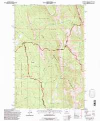
1995 Map of Porphyry Reef
USGS Topo · Published 1997About this map
The Continental Divide serves as the central spine of this mid-1990s wilderness survey, separating the Flathead National Forest to the west from the Lewis and Clark National Forest to the east. This high-altitude landscape is dominated by the Bob Marshall Wilderness, where dramatic geologic formations like Washboard Reef and Porphyry Reef Creek define the drainage patterns. The map highlights a critical network of backcountry routes, including the Continental Divide Scenic Trail and the C D N S T, which navigate through Sun River Pass and Teton Pass. South of the divide, the Sun River Game Preserve encompasses the headwaters of the North Fork Sun River. Notable clearings and landmarks such as Mc Donald Park and Grizzly Park provide reference points amidst the steep terrain of Spotted Bear Mountain and Wrong Ridge.
Find a feature on this map
40 named features on this map. Tap any name to fly to it.
Don’t see what you’re looking for? This feature index may not catch every label — zoom into the map to look around manually.
Map Details
Editions of this 1995 Porphyry Reef Map
This is the sole edition of this map. No revisions or reprints were ever made.
Other maps of this area

1903 · Saypo
USGS Topo · 1:125,000

1913 · Marias Pass
USGS Topo · 1:125,000

1914 · Heart Butte
USGS Topo · 1:125,000

1918 · Heart Butte
USGS Topo · 1:125,000

1936 · Silvertip
USGS Topo · 1:96,000

1942 · Silvertip
USGS Topo · 1:125,000

1955 · Choteau
USGS Topo · 1:250,000

1957 · Choteau
USGS Topo · 1:250,000

1958 · Choteau
USGS Topo · 1:250,000

1958 · Porphyry Reef
USGS Topo · 1:24,000