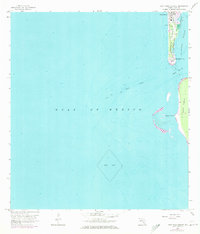
1958 Map of Port Boca Grande
USGS Topo · Published 1973About this map
Gasparilla Island serves as the focal point for this coastal survey, where the southern tip hosts the established community of Boca Grande and the industrial hub of Port Boca Grande. The map illustrates a critical maritime and rail intersection, featuring the terminus of the Seaboard Coast Line railroad and a prominent Lighthouse guarding the entrance to Charlotte Harbor. This 1973 photorevised edition documents the landscape as it stood in the late 1950s, with updates showing a Landing Field and residential expansion. Across the deep waters of the Boca Grande Channel lies Cayo Costa, marked by Murdock Point and the transition into the Gulf of Mexico. The inclusion of a large Spoil Area reflects the ongoing maintenance of the shipping lanes vital to the region's phosphate and maritime economy.
Find a feature on this map
12 named features on this map. Tap any name to fly to it.
Don’t see what you’re looking for? This feature index may not catch every label — zoom into the map to look around manually.
Map Details
Editions of this 1958 Port Boca Grande Map
5 editions found
Other maps of this area

1956 · Tampa
USGS Topo · 1:250,000

1956 · Charlotte Harbor
USGS Topo · 1:250,000

1957 · Punta Gorda SW
USGS Topo · 1:24,000

1957 · Placida
USGS Topo · 1:24,000

1958 · Captiva
USGS Topo · 1:24,000

1958 · Port Boca Grande
USGS Topo · 1:24,000

1958 · Bokeelia
USGS Topo · 1:24,000

1959 · Tampa
USGS Topo · 1:250,000

1960 · Tampa
USGS Topo · 1:250,000

1972 · Tampa
USGS Topo · 1:250,000