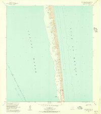
1955 Map of Port Isabel NW
USGS Topo · Published 1956About this map
Padre Island stretches across this mid-1950s survey as a landscape of shifting dunes and deposits, defined by extensive tracts of Sand and Mud along the coast. The transition from the open Gulf of Mexico to the sheltered waters of Laguna Madre reveals a barrier island environment before extensive modern development. Human engineering is visible in the Intracoastal Waterway, where a project depth of 12 feet is maintained alongside designated Spoil Areas. Near the southern portion of the island, Andy Bowie Park and a prominent Levee near Long Point indicate the early infrastructure of public spaces and coastal management. The presence of numerous Piles and a Light within the laguna underscores the importance of maritime navigation in this shallow estuary system.
Find a feature on this map
11 named features on this map. Tap any name to fly to it.
Don’t see what you’re looking for? This feature index may not catch every label — zoom into the map to look around manually.
Map Details
Editions of this 1955 Port Isabel NW Map
4 editions found
Other maps of this area

1929 · La Coma
USGS Topo · 1:24,000

1929 · Point Isabel
USGS Topo · 1:24,000

1929 · Buena Vista
USGS Topo · 1:24,000

1929 · Laguna Vista
USGS Topo · 1:24,000

1930 · Padre Island No. 1
USGS Topo · 1:24,000

1930 · Padre Island No. 2
USGS Topo · 1:24,000

1934 · Port Isabel
USGS Topo · 1:31,680

1934 · La Coma
USGS Topo · 1:31,680

1935 · Padre Island No 1
USGS Topo · 1:31,680

1935 · Padre Island NO. 2
USGS Topo · 1:31,680