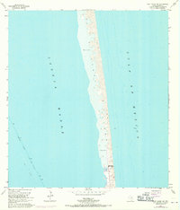
1955 Map of Port Isabel NW
USGS Topo · Published 1970About this map
Padre Island stretches between the shallow Laguna Madre and the open Gulf of Mexico, defined by its dynamic landscape of Shifting Sand Dunes and deposits of Sand and Mud. This 1955 survey, with 1970 revisions, captures the island's coastal geography before significant modern development, highlighting local landmarks like Andy Bowie Park and a designated Beach area. The hydrography reveals the essential Intracoastal Waterway cutting through the western waters, marked with Piles and a Light to navigate the Project Depth 12 Feet. Notable maritime features include a Wreck off the eastern shore and a landmark labeled Shark near the southern boundary. The presence of a Levee and various Spoil Areas underscores the ongoing human intervention required to maintain these vital shipping channels against the natural movement of the barrier island sands.
Find a feature on this map
15 named features on this map. Tap any name to fly to it.
Don’t see what you’re looking for? This feature index may not catch every label — zoom into the map to look around manually.
Map Details
Editions of this 1955 Port Isabel NW Map
4 editions found
Other maps of this area

1929 · La Coma
USGS Topo · 1:24,000

1929 · Point Isabel
USGS Topo · 1:24,000

1929 · Buena Vista
USGS Topo · 1:24,000

1929 · Laguna Vista
USGS Topo · 1:24,000

1930 · Padre Island No. 1
USGS Topo · 1:24,000

1930 · Padre Island No. 2
USGS Topo · 1:24,000

1934 · Port Isabel
USGS Topo · 1:31,680

1934 · La Coma
USGS Topo · 1:31,680

1935 · Padre Island No 1
USGS Topo · 1:31,680

1935 · Padre Island NO. 2
USGS Topo · 1:31,680