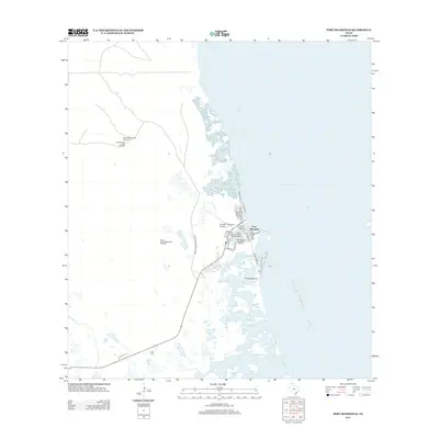
2013 Map of Port Mansfield
USGS Topo · Published 2013About this map
Port Mansfield serves as a critical maritime hub on the Texas coast, centered around its extensive boating infrastructure. This coastal landscape is defined by the sheltered waters of Red Fish Bay and the complex tidal marshes of Fourmile Slough, which separate the mainland from El Sauz Island. The settlement pattern reflects a dedicated fishing and navigation economy, with multiple facilities including the Willacy County Navigation District Marina and the Port Mansfield Boat Basin Marina catering to the community. Beyond the concentrated street grid of the port, the terrain transitions into a more traditional ranching or utility landscape. The presence of several named water sources such as Palmital Well North Windmill and Julian Well suggest the necessary infrastructure for sustaining life and livestock in this coastal environment, while Farm-to-Market Road 606 provides the primary overland connection to the interior.
Find a feature on this map
32 named features on this map. Tap any name to fly to it.
Don’t see what you’re looking for? This feature index may not catch every label — zoom into the map to look around manually.
Map Details
Editions of this 2013 Port Mansfield Map
This is the sole edition of this map. No revisions or reprints were ever made.
Other maps of this area

1921 · Tarida Ranch
USGS Topo · 1:62,500

1951 · South of Potrero Lopeno NE
USGS Topo · 1:24,000

1952 · Green Island
USGS Topo · 1:24,000

1952 · South of Potrero Lopeno NW
USGS Topo · 1:24,000

1952 · South of Potrero Lopeno SE
USGS Topo · 1:24,000

1952 · Hawk Island
USGS Topo · 1:24,000

1952 · Port Mansfield
USGS Topo · 1:24,000

1952 · South of Potrero Lopeno
USGS Topo · 1:62,500

1953 · Brownsville
USGS Topo · 1:250,000
1955 · La Leona
USGS Topo · 1:62,500