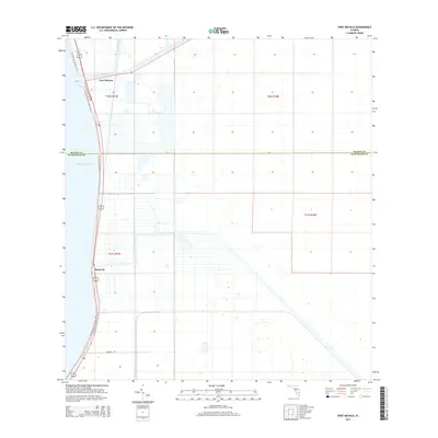
2015 Map of Port Mayaca
USGS Topo · Published 2015About this map
Lake Okeechobee dominates the western edge of this landscape where the Saint Lucie Canal begins its eastward journey toward the Atlantic. This hydraulic nexus at Port Mayaca represents a critical junction in South Florida’s water management history, showing the engineered transition from the great lake to the canal system. The map details a highly organized agricultural grid south of the waterway, bisected by the L-65 Canal and several section boundaries including t40s r37e and t41s r37e. Along the eastern shore of the lake, the Florida National Scenic Trail follows the levee, providing a recreational corridor through this working landscape. Further south along the shore, the small settlement of Sand Cut sits near the junction of coastal highways and rural tracks like Ammons Rd, marking the thin strip of habitable land between the vast sugar fields and the water's edge.
Find a feature on this map
12 named features on this map. Tap any name to fly to it.
Don’t see what you’re looking for? This feature index may not catch every label — zoom into the map to look around manually.
Map Details
Editions of this 2015 Port Mayaca Map
This is the sole edition of this map. No revisions or reprints were ever made.
Other maps of this area

1953 · Okeechobee 4 SW
USGS Topo · 1:24,000

1953 · Okeechobee 4 SE
USGS Topo · 1:24,000

1953 · Indian Town
USGS Topo · 1:24,000

1956 · West Palm Beach
USGS Topo · 1:250,000

1956 · Fort Pierce
USGS Topo · 1:250,000

1957 · West Palm Beach
USGS Topo · 1:250,000

1958 · Fort Pierce
USGS Topo · 1:250,000

1958 · West Palm Beach
USGS Topo · 1:250,000

1959 · Fort Pierce
USGS Topo · 1:250,000

1970 · West Palm Beach 2 SW
USGS Topo · 1:24,000