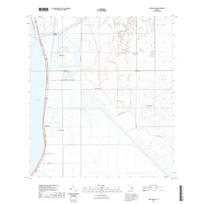
2021 Map of Port Mayaca
USGS Topo · Published 2021About this map
Port Mayaca stands at the strategic junction where the Saint Lucie Canal meets the eastern shore of Lake Okeechobee, serving as a vital node in the Okeechobee Waterway. This landscape is defined by its complex water management and recreational trail systems, featuring the Florida National Scenic Trl which follows the levee shoreline southward toward Sand Cut. Further inland, the map reveals a transition into the conservation lands of the Dupuis Reserve Trl, characterized by a web of interconnected paths like the East Loop 2 Trl and West Loop 1 Trl. Local infrastructure is marked by agricultural access roads such as Morning Star Farms Rd and the descriptively named Hole In The Wall Rd, illustrating the intersection of large-scale water engineering and Florida's rural interior at the start of the 2020s.
Find a feature on this map
23 named features on this map. Tap any name to fly to it.
Don’t see what you’re looking for? This feature index may not catch every label — zoom into the map to look around manually.
Map Details
Editions of this 2021 Port Mayaca Map
This is the sole edition of this map. No revisions or reprints were ever made.
Other maps of this area

1953 · Okeechobee 4 SW
USGS Topo · 1:24,000

1953 · Okeechobee 4 SE
USGS Topo · 1:24,000

1953 · Indian Town
USGS Topo · 1:24,000

1956 · West Palm Beach
USGS Topo · 1:250,000

1956 · Fort Pierce
USGS Topo · 1:250,000

1957 · West Palm Beach
USGS Topo · 1:250,000

1958 · Fort Pierce
USGS Topo · 1:250,000

1958 · West Palm Beach
USGS Topo · 1:250,000

1959 · Fort Pierce
USGS Topo · 1:250,000

1970 · West Palm Beach 2 SW
USGS Topo · 1:24,000