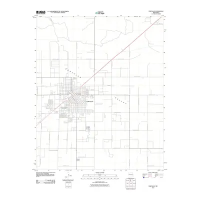
2010 Map of Portales
USGS Topo · Published 2010About this map
Portales serves as the focal point of this Eastern New Mexico landscape, situated within the broad Portales Valley. The town's grid is characterized by the expansive campus of Eastern New Mexico University and the central Portales Post Office. As a regional hub in Roosevelt County, the area is defined by a dense network of sectional roads like S Roosevelt Road 3 and S Roosevelt Road 8 that serve the surrounding agricultural and residential developments. To the south, the Rest Lawn Memorial Cemetery and Virginia Estates Subd Rd mark the transition toward more rural terrain. Smaller pockets of settlement, such as Mesilla Park in the northeast, underscore the community's outward growth along established corridors at the start of the 21st century.
Find a feature on this map
35 named features on this map. Tap any name to fly to it.
Don’t see what you’re looking for? This feature index may not catch every label — zoom into the map to look around manually.
Map Details
Editions of this 2010 Portales Map
This is the sole edition of this map. No revisions or reprints were ever made.
Other maps of this area

1954 · Clovis
USGS Topo · 1:250,000

1957 · Portair
USGS Topo · 1:62,500

1957 · Clovis
USGS Topo · 1:62,500

1957 · Arch
USGS Topo · 1:62,500

1957 · Portales
USGS Topo · 1:62,500

1958 · Clovis
USGS Topo · 1:250,000

1985 · Midway
USGS Topo · 1:24,000
1985 · Portales SE
USGS Topo · 1:24,000
1985 · Delphos
USGS Topo · 1:24,000
1985 · Arch
USGS Topo · 1:24,000