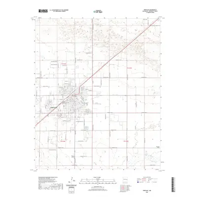
2020 Map of Portales
USGS Topo · Published 2020About this map
Portales serves as the focal point of this Roosevelt County study, showcasing a dense urban grid surrounded by the agricultural expanse of the Portales Valley. The map highlights central civic and educational landmarks, including the Roosevelt County Courthouse and the extensive Eastern New Mexico University Main Campus. Beyond the city limits, the landscape transitions into a systematic grid of section roads, such as S Roosevelt Road 4 and S Roosevelt Road 8, which define the local township and range boundaries. In the southeast, Portales Spring provides a distinct hydrological feature in an otherwise arid terrain. Small clusters of development like Bingham Stratton and the Loma Vista Rd area illustrate the residential patterns outside the primary city center, while Rest Lawn Memorial Park Cem sits along the southern corridor near the high plains edge.
Find a feature on this map
122 named features on this map. Tap any name to fly to it.
Don’t see what you’re looking for? This feature index may not catch every label — zoom into the map to look around manually.
Map Details
Editions of this 2020 Portales Map
This is the sole edition of this map. No revisions or reprints were ever made.
Other maps of this area

1954 · Clovis
USGS Topo · 1:250,000

1957 · Portair
USGS Topo · 1:62,500

1957 · Clovis
USGS Topo · 1:62,500

1957 · Arch
USGS Topo · 1:62,500

1957 · Portales
USGS Topo · 1:62,500

1958 · Clovis
USGS Topo · 1:250,000

1985 · Midway
USGS Topo · 1:24,000
1985 · Portales SE
USGS Topo · 1:24,000
1985 · Delphos
USGS Topo · 1:24,000
1985 · Arch
USGS Topo · 1:24,000