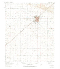
1957 Map of Portales
USGS Topo · Published 1976About this map
The Portales Valley defines this section of the High Plains, where the Atchison Topeka and Santa Fe railroad corridor anchors the regional economy. Portales serves as the central hub, home to Eastern New Mexico University and an expanding municipal grid including a Fairground, Municipal Airport, and several local schools like Lindsey Sch. The surrounding landscape is a mix of agricultural and ranching interests, evidenced by family-named holdings such as Ribble Ranch, Compton Ranch, and the Parrish Farm. Rural life is further marked by small communities like Bethel and Delphos, each connected by a network of roads that follow the section lines of the flat terrain. Local history and genealogy are preserved at sites like Bethel Cem and Steiner Cem, while the natural drainage of Boone Draw provides one of the few breaks in the steady topography of the plains.
Find a feature on this map
26 named features on this map. Tap any name to fly to it.
Don’t see what you’re looking for? This feature index may not catch every label — zoom into the map to look around manually.
Map Details
Editions of this 1957 Portales Map
2 editions found
Other maps of this area

1954 · Clovis
USGS Topo · 1:250,000

1954 · Brownfield
USGS Topo · 1:250,000

1957 · Portair
USGS Topo · 1:62,500

1957 · Melrose
USGS Topo · 1:62,500

1957 · Clovis
USGS Topo · 1:62,500

1957 · Arch
USGS Topo · 1:62,500

1957 · Portales
USGS Topo · 1:62,500

1958 · Brownfield
USGS Topo · 1:250,000

1958 · Clovis
USGS Topo · 1:250,000

1962 · Brownfield
USGS Topo · 1:250,000