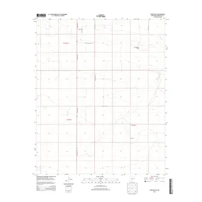
2013 Map of Portales SE
USGS Topo · Published 2013About this map
Agricultural operations and expansive ranch lands define this portion of the Llano Estacado in Roosevelt County. The landscape is organized by a precise grid of county roads and the primary north-south artery of New Mexico 206. This survey reveals the infrastructure of the local dairy and cattle industry, highlighting specialized operations like the Back Nine Dairy in the northeast and the Howl Ranch further south. The map illustrates the transition from open grazing land to more intensive livestock production facilities, with the land divided into the townships of t2s r35e and t3s r35e. Residential and farmstead access is facilitated by a network of local thoroughfares including Mooreland Rd, Honey Ln, and S Roosevelt Road Q.
Find a feature on this map
13 named features on this map. Tap any name to fly to it.
Don’t see what you’re looking for? This feature index may not catch every label — zoom into the map to look around manually.
Map Details
Editions of this 2013 Portales SE Map
This is the sole edition of this map. No revisions or reprints were ever made.
Other maps of this area

1954 · Clovis
USGS Topo · 1:250,000

1954 · Brownfield
USGS Topo · 1:250,000

1957 · Arch
USGS Topo · 1:62,500

1957 · Portales
USGS Topo · 1:62,500

1958 · Brownfield
USGS Topo · 1:250,000

1958 · Clovis
USGS Topo · 1:250,000

1962 · Brownfield
USGS Topo · 1:250,000

1972 · Dora NW
USGS Topo · 1:24,000
1972 · Causey West
USGS Topo · 1:24,000

1972 · Dora
USGS Topo · 1:24,000