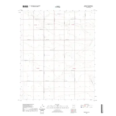
2020 Map of Portales SE
USGS Topo · Published 2020About this map
High plains ranching and agricultural patterns define this section of Roosevelt County, where a rigid grid of section-line roads structures the landscape. The primary north-south corridor of Dora Main St serves as a central artery for the region, connecting a series of rural routes that facilitate movement between vast agricultural tracts. This 2020 survey illustrates the systematic division of the land through the Public Land Survey System, specifically within township and range sections t2s r34e, t2s r35e, t3s r34e, and t3s r35e. The absence of dense settlements underscores the area's specialized character as a site of large-scale land management. Topographical variations are subtle, with numerous shallow depressions and basins scattered across the terrain, reflecting the unique drainage characteristics of the Llano Estacado region. Key local connectors include S Roosevelt Rd S and S Roosevelt Rd Q, which provide essential access for local residents and industry.
Find a feature on this map
21 named features on this map. Tap any name to fly to it.
Don’t see what you’re looking for? This feature index may not catch every label — zoom into the map to look around manually.
Map Details
Editions of this 2020 Portales SE Map
This is the sole edition of this map. No revisions or reprints were ever made.
Other maps of this area

1954 · Clovis
USGS Topo · 1:250,000

1954 · Brownfield
USGS Topo · 1:250,000

1957 · Arch
USGS Topo · 1:62,500

1957 · Portales
USGS Topo · 1:62,500

1958 · Brownfield
USGS Topo · 1:250,000

1958 · Clovis
USGS Topo · 1:250,000

1962 · Brownfield
USGS Topo · 1:250,000

1972 · Dora NW
USGS Topo · 1:24,000
1972 · Causey West
USGS Topo · 1:24,000

1972 · Dora
USGS Topo · 1:24,000