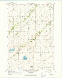
1967 Map of Porter SW
USGS Topo · Published 1968About this map
The Yellow Medicine River and its North Branch Yellow Medicine River carve a winding course through this southwestern Minnesota agricultural landscape. Spanning the townships of Marble, Alta Vista, Royal, and Limestone, the map captures the rural structure of Lincoln County in the late 1960s. The land is organized by a network of section roads, interspersed with significant local landmarks like the Townhall and several community burial grounds, including the Porter Cem and the St Johns Cantius Cem. Conservation efforts are visible in the central portion of the sheet at the Poposki State Wildlife Management Area, which encompasses Drietz Lake. In the northeast corner, the Chicago and North Western railroad cuts across the prairie, while numerous Gravel Pits suggest the importance of local material extraction for the region's infrastructure.
Find a feature on this map
18 named features on this map. Tap any name to fly to it.
Don’t see what you’re looking for? This feature index may not catch every label — zoom into the map to look around manually.
Map Details
Editions of this 1967 Porter SW Map
This is the sole edition of this map. No revisions or reprints were ever made.
Other maps of this area

1953 · Watertown
USGS Topo · 1:250,000

1958 · Watertown
USGS Topo · 1:250,000

1963 · Gislason Lake
USGS Topo · 1:24,000

1963 · Arco
USGS Topo · 1:24,000

1967 · Canby
USGS Topo · 1:24,000

1967 · Porter
USGS Topo · 1:24,000
1967 · St Leo
USGS Topo · 1:24,000
1967 · Taunton
USGS Topo · 1:24,000

1967 · Canby SE
USGS Topo · 1:24,000

1967 · Lake Benton NE
USGS Topo · 1:24,000