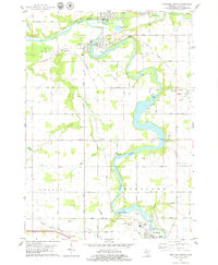
1978 Map of Portland North
USGS Topo · Published 1979About this map
The Grand River and Maple River converge in this mid-1970s landscape, shaping the industrial and social development of eastern Ionia County. The villages of Muir and Lyons sit at this river junction, where several gravel pits and the Chesapeake and Ohio railroad grade indicate a local economy tied to both resource extraction and transportation. To the south, the city of Portland is centered near the Portland Municipal Dam, which along with Webber Dam and Wagar Dam, demonstrates the extensive hydroelectric and water management infrastructure of the era.
Find a feature on this map
58 named features on this map. Tap any name to fly to it.
Don’t see what you’re looking for? This feature index may not catch every label — zoom into the map to look around manually.
Map Details
Editions of this 1978 Portland North Map
This is the sole edition of this map. No revisions or reprints were ever made.
Other maps of this area

1916 · Ionia
USGS Topo · 1:62,500

1918 · Ionia
USGS Topo · 1:62,500

1943 · Ionia
USGS Topo · 1:62,500

1945 · Portland
USGS Topo · 1:62,500

1954 · Midland
USGS Topo · 1:250,000

1958 · Midland
USGS Topo · 1:250,000

1958 · Grand Rapids
USGS Topo · 1:250,000

1959 · Midland
USGS Topo · 1:250,000

1961 · Grand Rapids
USGS Topo · 1:250,000

1962 · Grand Rapids
USGS Topo · 1:250,000