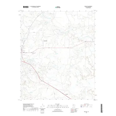
2019 Map of Post East
USGS Topo · Published 2019About this map
The high plains and rugged breaks of Garza County are defined by the N Fork Double Mountain Fork Brazos River as it carves through the landscape northeast of Post. This map reveals a complex network of intermittent drainages and ranching infrastructure, characterized by numerous stock tanks like Stink Cr Tank, Turtle Tank, and Crawfish Tank that dot the arid terrain. The settlement of Post sits at the edge of the caprock, with its residential streets transitioning into the rural reaches of the Post-Garza County Municipal Airport. To the southeast, the small community of Augustus marks a point along the roadway, while local history is anchored at the Terrace Cem. The drainage patterns of Stink Cr, Sand Cr, and Rattlesnake Cr illustrate the erosional forces shaping this portion of the Texas Panhandle edge.
Find a feature on this map
29 named features on this map. Tap any name to fly to it.
Don’t see what you’re looking for? This feature index may not catch every label — zoom into the map to look around manually.
Map Details
Editions of this 2019 Post East Map
This is the sole edition of this map. No revisions or reprints were ever made.
Other maps of this area

1954 · Lubbock
USGS Topo · 1:250,000

1968 · South Dokegood Creek
USGS Topo · 1:24,000

1969 · Verbena
USGS Topo · 1:24,000

1969 · Cap Rock SE
USGS Topo · 1:24,000
1969 · Justiceburg NW
USGS Topo · 1:24,000

1969 · Post East
USGS Topo · 1:24,000

1969 · Justiceburg
USGS Topo · 1:24,000

1969 · Post West
USGS Topo · 1:24,000

1969 · Cooper Creek
USGS Topo · 1:24,000
1969 · Middle Creek
USGS Topo · 1:24,000