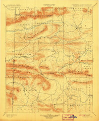
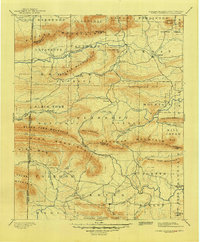
1899 Map of Poteau Mountain
USGS Topo · Published 1908About this map
Poteau Mountain and the surrounding Ouachita highlands defined the borderlands of Scott and Polk counties during this late 19th-century survey. The terrain is characterized by massive east-west ridges including Black Fork Mountain and Rich Mountain, which served as formidable barriers to early transit. Settlement was concentrated in the more accessible valleys near Waldron and Dallas, where community life was anchored by remote post offices such as Cherry Hill (Egger P.O.).
Find a feature on this map
75 named features on this map. Tap any name to fly to it.
Don’t see what you’re looking for? This feature index may not catch every label — zoom into the map to look around manually.
Map Details
Editions of this 1899 Poteau Mountain Map
6 editions found

Other maps of this area

1879 · Poteau Mountain
USGS Topo · 1:62,500

1887 · Poteau Mountain #1
USGS Topo · 1:62,500

1887 · Mount Ida #2
USGS Topo · 1:62,500

1887 · Magazine Mountain #3
USGS Topo · 1:62,500

1887 · Magazine Mountain
USGS Topo · 1:62,500

1887 · Poteau Mountain #2
USGS Topo · 1:62,500

1887 · Greenwood
USGS Topo · 1:62,500

1890 · Magazine Mountain
USGS Topo · 1:125,000

1890 · Mount Ida
USGS Topo · 1:125,000

1890 · Fort Smith
USGS Topo · 1:125,000