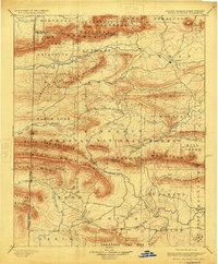
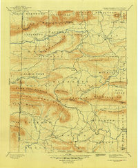
1899 Map of Poteau Mountain
USGS Topo · Published 1924About this map
The Indian Territory Arkansas boundary line defines the western edge of this landscape, surveyed in 1887 before Oklahoma statehood. This mountainous region of Arkansas National Forest is anchored by the settlement of Waldron, where the Fourche La Fave River begins its eastward flow. The terrain is marked by massive ridges including Poteau Mountain and Rich Mountain, which shaped the early road networks and isolated rural outposts like Cauthron and Blansett.
Find a feature on this map
73 named features on this map. Tap any name to fly to it.
Don’t see what you’re looking for? This feature index may not catch every label — zoom into the map to look around manually.
Map Details
Editions of this 1899 Poteau Mountain Map
6 editions found

Other maps of this area

1879 · Poteau Mountain
USGS Topo · 1:62,500

1887 · Poteau Mountain #1
USGS Topo · 1:62,500

1887 · Mount Ida #2
USGS Topo · 1:62,500

1887 · Magazine Mountain #3
USGS Topo · 1:62,500

1887 · Magazine Mountain
USGS Topo · 1:62,500

1887 · Poteau Mountain #2
USGS Topo · 1:62,500

1887 · Greenwood
USGS Topo · 1:62,500

1890 · Magazine Mountain
USGS Topo · 1:125,000

1890 · Mount Ida
USGS Topo · 1:125,000

1890 · Fort Smith
USGS Topo · 1:125,000