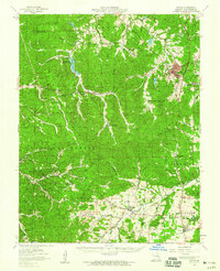
1958 Map of Potosi
USGS Topo · Published 1959About this map
Potosi anchors the northeastern corner of this Washington County landscape, a region defined by its long-standing mining operations and the vast acreage of the Clark National Forest. In the late 1950s, the area retained a strong network of rural institutions, including the Shirley Sch and Valley High Sch, alongside numerous country congregations like Glory Hill Ch and Marler Chapel. The terrain is deeply dissected by watercourses such as Fourche a Renault and Big River, which influenced the placement of early settlements like Belgrade and Caledonia. For those researching local families, the presence of the Marble Cem, McClain Cem, and Caledonia Cem provides specific points of interest for genealogical study within this heavily wooded and mineral-rich portion of the Missouri Ozarks.
Find a feature on this map
61 named features on this map. Tap any name to fly to it.
Don’t see what you’re looking for? This feature index may not catch every label — zoom into the map to look around manually.
Map Details
Editions of this 1958 Potosi Map
3 editions found
Other maps of this area

1901 · De Soto
USGS Topo · 1:125,000

1903 · Sullivan
USGS Topo · 1:125,000

1905 · Bonneterre
USGS Topo · 1:62,500

1906 · Potosi
USGS Topo · 1:62,500

1924 · Edgehill
USGS Topo · 1:62,500

1926 · Edgehill
USGS Topo · 1:62,500

1937 · Ironton
USGS Topo · 1:48,000

1937 · Tiff
USGS Topo · 1:24,000

1939 · Tiff
USGS Topo · 1:24,000

1943 · Berryman
USGS Topo · 1:62,500