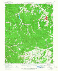
1958 Map of Potosi
USGS Topo · Published 1968About this map
Potosi serves as the focal point of this late-1950s survey of Washington County, showing the town at the intersection of local industry and the Missouri Pacific railroad. The landscape is heavily marked by its mineral history, with numerous mines and tailing ponds scattered near the town center and extending toward Springtown. The Clark National Forest encompasses much of the western terrain, where isolated settlements like Palmer and Delbridge are reached by winding roads through the timber.
Find a feature on this map
71 named features on this map. Tap any name to fly to it.
Don’t see what you’re looking for? This feature index may not catch every label — zoom into the map to look around manually.
Map Details
Editions of this 1958 Potosi Map
3 editions found
Other maps of this area

1901 · De Soto
USGS Topo · 1:125,000

1903 · Sullivan
USGS Topo · 1:125,000

1905 · Bonneterre
USGS Topo · 1:62,500

1906 · Potosi
USGS Topo · 1:62,500

1924 · Edgehill
USGS Topo · 1:62,500

1926 · Edgehill
USGS Topo · 1:62,500

1937 · Ironton
USGS Topo · 1:48,000

1937 · Tiff
USGS Topo · 1:24,000

1939 · Tiff
USGS Topo · 1:24,000

1943 · Berryman
USGS Topo · 1:62,500