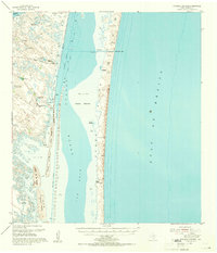
1955 Map of Potrero Cortado
USGS Topo · Published 1956About this map
Laguna Madre separates the South Texas mainland from the shifting sands of Padre Island in this mid-century coastal survey. The landscape is defined by the shallow, hypersaline waters of The Hole and the Middle Ground, where navigation is dictated by the Intracoastal Waterway. On the mainland, ranching interests are evident at Carnestolendas Ranch and Mota Negra, supported by a critical network of artesian sources including Picacho Nuevo Artesian Well and Richards Artesian Well. The name "potrero" appears frequently across features like Potrero Cortado and Potrero de los Caballos, indicating historical pasture grounds enclosed by natural water boundaries or sloughs like Rocky Slough. This map captures the coastal environment before significant modern development, showing isolated outposts like Dunns Ranch and the natural break at Yarborough Pass.
Find a feature on this map
28 named features on this map. Tap any name to fly to it.
Don’t see what you’re looking for? This feature index may not catch every label — zoom into the map to look around manually.
Map Details
Editions of this 1955 Potrero Cortado Map
2 editions found
Other maps of this area

1923 · Lopena Island
USGS Topo · 1:62,500

1923 · Saltillo Ranch
USGS Topo · 1:62,500

1928 · Sarita
USGS Topo · 1:125,000

1950 · Corpus Christi
USGS Topo · 1:250,000

1951 · South Bird Island SE
USGS Topo · 1:24,000

1951 · Point Of Rocks
USGS Topo · 1:24,000

1951 · Kleberg Point
USGS Topo · 1:24,000

1951 · Potrero Lopeno NW
USGS Topo · 1:24,000

1951 · Sarita 4 NE
USGS Topo · 1:24,000

1951 · South Bird Island
USGS Topo · 1:62,500