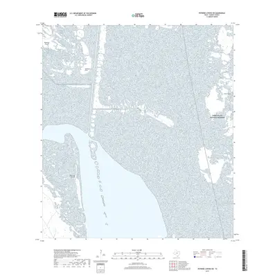
2019 Map of Potrero Lopeno SW
USGS Topo · Published 2019About this map
The coastal wetlands and tidal flats of Kenedy County define this 2019 survey, where the mainland meets the hypersaline waters of the Laguna Madre. This specific environment is characterized by large, low-lying landforms known locally as rincons, including Mesquite Rincon in the northwest and the expansive Rincon de San Jose to the south. These features are significant for understanding the historical geography of the Texas coast, representing slightly elevated ground amidst the shifting sands and mudflats. The eastern edge of the quadrangle includes the protected expanse of Padre Island National Seashore on Padre Island, a critical barrier system that separates the lagoon from the Gulf. Human infrastructure is minimal in this remote section of the county, marked primarily by E Turcotte Rd and the navigational marker at Southeast Point.
Find a feature on this map
6 named features on this map. Tap any name to fly to it.
Don’t see what you’re looking for? This feature index may not catch every label — zoom into the map to look around manually.
Map Details
Editions of this 2019 Potrero Lopeno SW Map
This is the sole edition of this map. No revisions or reprints were ever made.
Other maps of this area

1921 · Tarida Ranch
USGS Topo · 1:62,500

1923 · Lopena Island
USGS Topo · 1:62,500

1923 · Saltillo Ranch
USGS Topo · 1:62,500

1951 · South of Potrero Lopeno NE
USGS Topo · 1:24,000

1951 · Potrero Lopeno NW
USGS Topo · 1:24,000

1952 · Potrero Lopeno SE
USGS Topo · 1:24,000

1952 · South of Potrero Lopeno NW
USGS Topo · 1:24,000

1952 · Potrero Lopeno SW
USGS Topo · 1:24,000

1952 · Potrero Lopeno
USGS Topo · 1:62,500

1952 · South of Potrero Lopeno
USGS Topo · 1:62,500