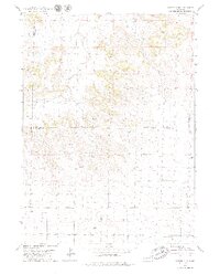
1979 Map of Potter 2 NE
USGS Topo · Published 1979About this map
Lawrence Fork cuts through this High Plains landscape, which serves as a notable intersection of energy extraction and aviation in the late 1970s. The terrain is marked by a significant Oil Field, with numerous Oil Wells distributed across the prairie, indicating the region's industrial footprint during this era. Toward the eastern edge, the Mayer Landing Strip provides a specific point of interest for those researching local transport and ranching infrastructure. This document also delineates the complex jurisdictional boundaries where Morrill County meets Banner County and Cheyenne County, while reflecting the physical impact of resource extraction through several documented Gravel Pits.
Find a feature on this map
8 named features on this map. Tap any name to fly to it.
Don’t see what you’re looking for? This feature index may not catch every label — zoom into the map to look around manually.
Map Details
Editions of this 1979 Potter 2 NE Map
2 editions found
Other maps of this area

1898 · Camp Clarke
USGS Topo · 1:125,000

1954 · Scottsbluff
USGS Topo · 1:250,000

1958 · Scottsbluff
USGS Topo · 1:250,000

1972 · Mud Springs SW
USGS Topo · 1:24,000

1972 · Horsehead Ranch
USGS Topo · 1:24,000

1973 · Potter 2 SW
USGS Topo · 1:24,000

1973 · Bridgeport SW
USGS Topo · 1:24,000

1973 · Potter 2 SE
USGS Topo · 1:24,000

1973 · Potter 2 NW
USGS Topo · 1:24,000
1973 · Potter 2 NE
USGS Topo · 1:24,000