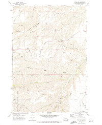
1971 Map of Potter Hill
USGS Topo · Published 1974About this map
Potter Hill rises above a landscape defined by deeply incised canyons and high grazing ridges in this early 1970s survey. The map details the transition from the high-altitude Umatilla National Forest in the southwest corner down through a complex network of named gulches and ridges toward the settlement of Cloverland. Water is the primary driver of geography here, with numerous family-named sources such as Faradyce Spring, Rimmelspacher Spring, and Laufer Spring providing essential resources for upland ranching. The eastern portion of the sheet is dominated by the Asotin Creek drainage and the distinctive Gooseneck bend. Local transit during this era relied heavily on a network of Jeep Trails and the Cloverland Road, which provided access to remote features like Tam Tam Ridge and Smoothing Iron Ridge.
Find a feature on this map
40 named features on this map. Tap any name to fly to it.
Don’t see what you’re looking for? This feature index may not catch every label — zoom into the map to look around manually.
Map Details
Editions of this 1971 Potter Hill Map
2 editions found
Other maps of this area

1943 · Peola
USGS Topo · 1:62,500

1943 · Saddle Butte
USGS Topo · 1:62,500

1944 · Anatone
USGS Topo · 1:62,500

1945 · Clarkston
USGS Topo · 1:62,500

1946 · Saddle Butte
USGS Topo · 1:62,500

1946 · Peola
USGS Topo · 1:62,500

1946 · Anatone
USGS Topo · 1:62,500

1948 · Clarkston
USGS Topo · 1:62,500

1955 · Pullman
USGS Topo · 1:250,000

1958 · Pullman
USGS Topo · 1:250,000