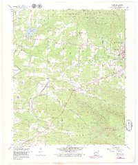
1958 Map of Potter
USGS Topo · Published 1979About this map
Mena serves as the primary hub on this survey, situated at the edge of the Ouachita National Forest where the railroad corridor dictates the local geography. The Kansas City Southern line links the smaller settlements of Potter and Potter Junction, providing a vital transit route through the valleys between Round Mtn and Potter Mountain. Numerous small cemeteries and country churches are scattered throughout the landscape, including Mt Gillian Cem and Gann Chapel, reflecting the established rural communities of the mid-20th century. Beyond the rail-centered towns, the map details a landscape transition from the industrial Quarry and Gravel Pit operations to the recreational waters of Lake Wilhelmina. Cultural landmarks such as the County Fairground and Golf Course on the outskirts of Mena further illustrate the area's development during this era of growth.
Find a feature on this map
41 named features on this map. Tap any name to fly to it.
Don’t see what you’re looking for? This feature index may not catch every label — zoom into the map to look around manually.
Map Details
Editions of this 1958 Potter Map
3 editions found
Other maps of this area

1890 · Poteau Mountain
USGS Topo · 1:125,000

1899 · Poteau Mountain
USGS Topo · 1:125,000

1913 · De Queen
USGS Topo · 1:125,000

1950 · Mcalester
USGS Topo · 1:250,000

1958 · Mena
USGS Topo · 1:62,500

1958 · Potter
USGS Topo · 1:62,500

1958 · Zafra
USGS Topo · 1:24,000

1958 · Mena
USGS Topo · 1:24,000

1958 · Rich Mountain
USGS Topo · 1:24,000
1958 · Potter
USGS Topo · 1:24,000