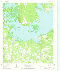
1962 Map of Potters Point
USGS Topo · Published 1978About this map
Caddo Lake and its intricate network of bayous and sloughs dominate this landscape along the Texas-Louisiana border in the early 1960s. The settlement of Uncertain and the prominent Potters Point overlook a complex aquatic geography defined by features like Whangdoodle Pass, Alligator Bayou, and Ames Spring Basin. The southern portion of the map reveals the industrial footprint of the Longhorn Ordnance Works, while the surrounding woodlands are dotted with rural landmarks including Elizabeth Ch, Blocker Ch, and a local Cemeterey. This survey captures the transition of the lake from a natural cypress wilderness to a managed waterway, evidenced by the Government Ditch and numerous oil wells. Genealogists can trace old family landing sites and crossings like Swansons Landing and Millers Pt, which remain tied to the river-and-rail history of Harrison and Marion counties.
Find a feature on this map
60 named features on this map. Tap any name to fly to it.
Don’t see what you’re looking for? This feature index may not catch every label — zoom into the map to look around manually.
Map Details
Editions of this 1962 Potters Point Map
Other maps of this area

1932 · Hosston SW
USGS Topo · 1:31,680

1944 · Kildare
USGS Topo · 1:62,500

1944 · Caddo Lake
USGS Topo · 1:62,500

1946 · Caddo Lake
USGS Topo · 1:62,500

1948 · Kildare
USGS Topo · 1:62,500

1948 · Mooringsport
USGS Topo · 1:62,500

1948 · Vivian
USGS Topo · 1:62,500

1955 · Shreveport
USGS Topo · 1:250,000

1955 · Mooringsport
USGS Topo · 1:62,500

1956 · Shreveport
USGS Topo · 1:250,000