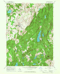
1960 Map of Poughquag
USGS Topo · Published 1967About this map
Green Haven State Prison dominates the central landscape of this 1960 Dutchess County survey, situated just north of the Stormville Airport. The region's mid-century character is defined by a mix of institutional grounds and clustered hamlets like Poughquag and Stormville. The New York New Haven and Hartford railroad cuts through the terrain, connecting these communities and skirting the base of Depot Hill.
Find a feature on this map
65 named features on this map. Tap any name to fly to it.
Don’t see what you’re looking for? This feature index may not catch every label — zoom into the map to look around manually.
Map Details
Editions of this 1960 Poughquag Map
4 editions found
Other maps of this area

1892 · West Point
USGS Topo · 1:62,500

1892 · Carmel
USGS Topo · 1:62,500

1893 · Carmel
USGS Topo · 1:62,500

1893 · Clove
USGS Topo · 1:62,500

1893 · Poughkeepsie
USGS Topo · 1:62,500

1894 · West Point
USGS Topo · 1:62,500

1894 · Clove
USGS Topo · 1:62,500

1894 · Carmel
USGS Topo · 1:62,500

1894 · Poughkeepsie
USGS Topo · 1:62,500

1898 · Clove
USGS Topo · 1:62,500