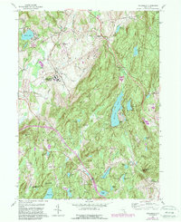
1960 Map of Poughquag
USGS Topo · Published 1988About this map
Green Haven Correctional Facility and the small hamlet of Green Haven occupy the lowlands of Beekman, where the landscape is defined by the intersection of industrial operations and rural summer camps. The mid-century character of this region is shaped by the Conrail rail line and the Stormville Airport, which sit just north of the significant rise of Stormville Mtn. This period shows a high density of organized camps, such as Sanita Hills Camp and Camp Ludington, scattered among numerous water bodies like Whaley Lake and Sylvan Lake. The Appalachian Trail winds through the southern ridges of Fishkill, passing near smaller settlements like Pecksville. Notable local history markers include the Beekman Cem and schools such as School No 1, which reflect the community's early 20th-century development alongside more modern revisions like the sewage disposal and gravel pits.
Find a feature on this map
64 named features on this map. Tap any name to fly to it.
Don’t see what you’re looking for? This feature index may not catch every label — zoom into the map to look around manually.
Map Details
Editions of this 1960 Poughquag Map
4 editions found
Other maps of this area

1892 · West Point
USGS Topo · 1:62,500

1892 · Carmel
USGS Topo · 1:62,500

1893 · Carmel
USGS Topo · 1:62,500

1893 · Clove
USGS Topo · 1:62,500

1893 · Poughkeepsie
USGS Topo · 1:62,500

1894 · West Point
USGS Topo · 1:62,500

1894 · Clove
USGS Topo · 1:62,500

1894 · Carmel
USGS Topo · 1:62,500

1894 · Poughkeepsie
USGS Topo · 1:62,500

1898 · Clove
USGS Topo · 1:62,500