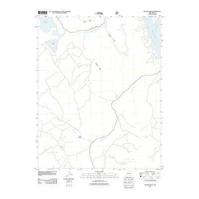
2011 Map of Pounds Mesa
USGS Topo · Published 2011About this map
Pounds Mesa dominates the central landscape of this Rio Arriba County region, where the high desert terrain is defined by dramatic mesas and seasonal drainage systems. The settlement of Puerto Chiquito serves as a lone human waypoint in an area primarily shaped by natural landforms and water management. To the northeast, the expanse of El Vado Reservoir meets the rugged topography of Railroad Canyon, while the northwestern corner is marked by the distinct alkaline waters of Stinking Lake and the nearby Horse Island. This 2011 survey documents the established infrastructure of State Hwy 112 as it winds through the arroyos, including the extensive Arroyo del Puerto Chiquito. The map illustrates a high-altitude environment where traditional names like Apache Mesa and La Puerta Grande reflect a deep cultural connection to the geography of Northern New Mexico.
Find a feature on this map
14 named features on this map. Tap any name to fly to it.
Don’t see what you’re looking for? This feature index may not catch every label — zoom into the map to look around manually.
Map Details
Editions of this 2011 Pounds Mesa Map
This is the sole edition of this map. No revisions or reprints were ever made.
Other maps of this area

1909 · Gallina
USGS Topo · 1:125,000

1953 · Navajo Peak
USGS Topo · 1:24,000

1954 · Aztec
USGS Topo · 1:250,000

1955 · Llaves
USGS Topo · 1:62,500

1955 · Tierra Amarilla
USGS Topo · 1:62,500

1955 · Boulder Lake
USGS Topo · 1:62,500

1958 · Aztec
USGS Topo · 1:250,000

1962 · Aztec
USGS Topo · 1:250,000

1965 · Aztec
USGS Topo · 1:250,000

1981 · Chama
USGS Topo · 1:100,000