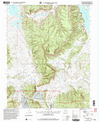
2002 Map of Pounds Mesa
USGS Topo · Published 2003About this map
The Jicarilla Apache Indian Reservation dominates the western half of this landscape, meeting the Tierra Amarilla Grant at a stark surveyed boundary. The terrain is characterized by high plateau features like Pounds Mesa and Mesa Grande, which drop into the deep drainage of Railroad Canyon. This 2002 revision shows a region defined by managed land and natural resources, where the northern reaches of the Santa Fe National Forest provide a wooded contrast to the more open reservation lands.
Find a feature on this map
18 named features on this map. Tap any name to fly to it.
Don’t see what you’re looking for? This feature index may not catch every label — zoom into the map to look around manually.
Map Details
Editions of this 2002 Pounds Mesa Map
This is the sole edition of this map. No revisions or reprints were ever made.
Other maps of this area

1909 · Gallina
USGS Topo · 1:125,000

1953 · Navajo Peak
USGS Topo · 1:24,000

1954 · Aztec
USGS Topo · 1:250,000

1955 · Llaves
USGS Topo · 1:62,500

1955 · Tierra Amarilla
USGS Topo · 1:62,500

1955 · Boulder Lake
USGS Topo · 1:62,500

1958 · Aztec
USGS Topo · 1:250,000

1962 · Aztec
USGS Topo · 1:250,000

1965 · Aztec
USGS Topo · 1:250,000

1981 · Chama
USGS Topo · 1:100,000