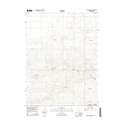
2015 Map of Powder Mountain
USGS Topo · Published 2015About this map
The Cherokee Trail Rd cuts through this high-altitude landscape along the border of Wyoming and Colorado, following a path beneath the prominent Powder Rim. This area of Sweetwater County is defined by its seasonal water management, featuring a dense network of catchments such as Carson Reservoir, Salt Lick Reservoir, and Two Draw Reservoir. These features, along with names like Moonshine Spring and Grindstone Spring, suggest a history of resource utilization in a demanding environment. To the south, the terrain rises toward Powder Mtn and Anthill Knob, while the intricate drainage systems of Grindstone Wash and Ruedloff Draw navigate the slopes of Ruedloff Ridge. The presence of the East Fork Anthill Draw and West Fork Anthill Draw further illustrates the complex erosion patterns of this desert mountain terrain.
Find a feature on this map
27 named features on this map. Tap any name to fly to it.
Don’t see what you’re looking for? This feature index may not catch every label — zoom into the map to look around manually.
Map Details
Editions of this 2015 Powder Mountain Map
This is the sole edition of this map. No revisions or reprints were ever made.
Other maps of this area

1954 · Vernal
USGS Topo · 1:250,000

1954 · Rock Springs
USGS Topo · 1:250,000

1958 · Vernal
USGS Topo · 1:250,000

1958 · Rock Springs
USGS Topo · 1:250,000

1960 · Vernal
USGS Topo · 1:250,000

1962 · Rock Springs
USGS Topo · 1:250,000

1969 · Reservoir Draw
USGS Topo · 1:24,000
1969 · The Nipple NE
USGS Topo · 1:24,000

1969 · Powder Wash
USGS Topo · 1:24,000

1970 · Prehistoric Rim
USGS Topo · 1:24,000