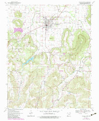
1970 Map of Prairie Grove
USGS Topo · Published 1983About this map
Prairie Grove Battlefield State Park anchors the northern portion of this survey, marking the site of a pivotal Civil War conflict. The landscape is defined by the winding Illinois River and its tributaries, including Muddy Fork Creek and Budd Kidd Creek. The terrain transitions from the developed streets of Prairie Grove to the prominent heights of Stevenson Mountain and the Pinnacle.
Find a feature on this map
33 named features on this map. Tap any name to fly to it.
Don’t see what you’re looking for? This feature index may not catch every label — zoom into the map to look around manually.
Map Details
Editions of this 1970 Prairie Grove Map
4 editions found
Other maps of this area

1898 · Winslow
USGS Topo · 1:125,000

1899 · Fayetteville
USGS Topo · 1:125,000

1901 · Winslow
USGS Topo · 1:125,000

1901 · Fayetteville
USGS Topo · 1:125,000

1904 · Fayetteville
USGS Topo · 1:125,000

1946 · Fort Smith
USGS Topo · 1:250,000

1954 · Tulsa
USGS Topo · 1:250,000

1958 · Fayetteville
USGS Topo · 1:24,000

1958 · Tulsa
USGS Topo · 1:250,000

1963 · Tulsa
USGS Topo · 1:250,000