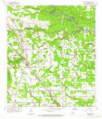
1963 Map of Prairieville
USGS Topo · Published 1964About this map
Amite River meanders across the northeastern corner of this Ascension Parish survey, defining the border with Livingston Parish through a series of dramatic oxbows and bends, including Horseshoe Bend and Horseshoe Lake. The landscape is a network of bayous and low-lying wetlands, with Manchac Bayou and Boggy Bayou draining the northern territory. Human settlement is concentrated along the higher ground and major thoroughfares, particularly the Kansas City Southern railroad line which serves the community of Prairieville. This mid-century snapshot reveals a rural economy shifting between traditional swamp-related activities and increasing infrastructure development. Scattered throughout the area are numerous local landmarks vital for genealogical research, such as Prairieville School, Galvez Cemetery, and smaller hamlets like Dutch Town, Duplessis, and Hope Villa, each anchored by neighborhood institutions like St Paul Church and Hillman Chapel.
Find a feature on this map
58 named features on this map. Tap any name to fly to it.
Don’t see what you’re looking for? This feature index may not catch every label — zoom into the map to look around manually.
Map Details
Editions of this 1963 Prairieville Map
4 editions found
Other maps of this area

1892 · Donaldsonville
USGS Topo · 1:62,500

1908 · Baton Rouge
USGS Topo · 1:62,500

1934 · Denham Springs
USGS Topo · 1:62,500

1935 · Gonzales
USGS Topo · 1:31,680

1936 · White Castle
USGS Topo · 1:62,500

1939 · Denham Springs
USGS Topo · 1:62,500

1939 · Baton Rouge
USGS Topo · 1:62,500

1939 · Donaldsonville
USGS Topo · 1:62,500

1947 · Sorrento
USGS Topo · 1:31,680

1953 · Walker
USGS Topo · 1:24,000