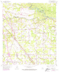
1963 Map of Prairieville
USGS Topo · Published 1981About this map
The Amite River winds through the northeast corner of this map, forming a complex network of oxbows and backwaters including Horseshoe Bend and Ficklin Lake. South of the river, Bayou Manchac serves as a significant parish boundary, separating East Baton Rouge from Ascension Parish. The landscape is defined by the transition from the Bluff Swamp in the west to a more developed upland corridor where the Kansas City Southern railroad dictates the orientation of settlements like Prairieville and Duplessis. Local history is deeply rooted in these rural crossroads, evidenced by numerous community landmarks such as Prairieville Sch, Mt Gillion Ch, and Broussard Grove Ch. The presence of Oil Wells and Gas Wells suggests the early influence of the energy industry on this largely agrarian and swampy terrain.
Find a feature on this map
56 named features on this map. Tap any name to fly to it.
Don’t see what you’re looking for? This feature index may not catch every label — zoom into the map to look around manually.
Map Details
Editions of this 1963 Prairieville Map
4 editions found
Other maps of this area

1892 · Donaldsonville
USGS Topo · 1:62,500

1908 · Baton Rouge
USGS Topo · 1:62,500

1934 · Denham Springs
USGS Topo · 1:62,500

1935 · Gonzales
USGS Topo · 1:31,680

1936 · White Castle
USGS Topo · 1:62,500

1939 · Denham Springs
USGS Topo · 1:62,500

1939 · Baton Rouge
USGS Topo · 1:62,500

1939 · Donaldsonville
USGS Topo · 1:62,500

1947 · Sorrento
USGS Topo · 1:31,680

1953 · Walker
USGS Topo · 1:24,000