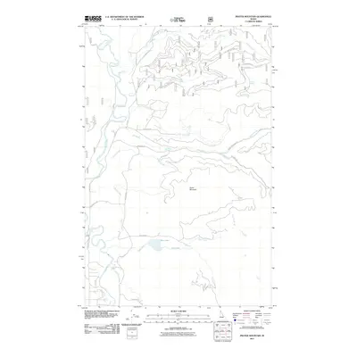
2011 Map of Prater Mountain
USGS Topo · Published 2011About this map
Prater Mountain serves as the central topographic focal point of this 2011 survey, overlooking a complex drainage system in the Idaho panhandle. The western edge is defined by the winding course of the Priest River, which receives the East River and Little Pine Creek as it flows south. Notable riparian features include the cascade at McAbee Falls and the secluded Blue Lake, which is fed by Blue Creek.
Find a feature on this map
36 named features on this map. Tap any name to fly to it.
Don’t see what you’re looking for? This feature index may not catch every label — zoom into the map to look around manually.
Map Details
Editions of this 2011 Prater Mountain Map
This is the sole edition of this map. No revisions or reprints were ever made.
Other maps of this area

1901 · Sandpoint
USGS Topo · 1:125,000

1911 · Priest Lake
USGS Topo · 1:250,000

1911 · Sandpoint
USGS Topo · 1:125,000

1913 · Priest Lake
USGS Topo · 1:250,000

1958 · Sandpoint
USGS Topo · 1:250,000

1963 · Sandpoint
USGS Topo · 1:250,000

1967 · Quartz Mtn
USGS Topo · 1:24,000

1967 · Coolin
USGS Topo · 1:24,000
1967 · Outlet Bay
USGS Topo · 1:24,000

1967 · Prater Mtn
USGS Topo · 1:24,000