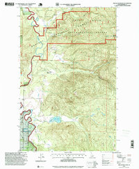
1996 Map of Prater Mountain
USGS Topo · Published 1999About this map
The Priest River Experimental Forest, established in the early 20th century as one of the nation's first forestry research stations, dominates this terrain in northern Idaho. The map documents the complex forest management infrastructure of the era, including the Experimental Forest Headquarters and the Sewage Disposal Pond near Benton Creek. The landscape is defined by the sharp descent from peaks like Gisborne Mountain and Prater Mountain down to the winding course of the Priest River. Along the river’s edge, markers of local navigation and land use appear, such as McAbee Falls and several scattered Gravel Pit sites. In the northwestern corner, the southern tip of Priest Lake is visible, while the interior of the Kaniksu National Forest is threaded by numerous drainage systems like Fox Creek and Blue Creek, which feeds into the secluded Blue Lake.
Find a feature on this map
26 named features on this map. Tap any name to fly to it.
Don’t see what you’re looking for? This feature index may not catch every label — zoom into the map to look around manually.
Map Details
Editions of this 1996 Prater Mountain Map
This is the sole edition of this map. No revisions or reprints were ever made.
Other maps of this area

1901 · Sandpoint
USGS Topo · 1:125,000

1911 · Priest Lake
USGS Topo · 1:250,000

1911 · Sandpoint
USGS Topo · 1:125,000

1913 · Priest Lake
USGS Topo · 1:250,000

1958 · Sandpoint
USGS Topo · 1:250,000

1963 · Sandpoint
USGS Topo · 1:250,000

1967 · Quartz Mtn
USGS Topo · 1:24,000

1967 · Coolin
USGS Topo · 1:24,000
1967 · Outlet Bay
USGS Topo · 1:24,000

1967 · Prater Mtn
USGS Topo · 1:24,000