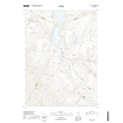
2019 Map of Prattsville
USGS Topo · Published 2019About this map
Prattsville sits at the confluence of Schoharie Creek and Batavia Kill, anchoring a landscape defined by the significant footprint of the Schoharie Reservoir to the north. This modern survey illustrates the persistent settlement patterns of the Catskills, where hamlets like Red Falls, North Lexington, and Grand Gorge follow the narrow valley floors between high peaks such as Bearpen Mtn and Sicklers Mtn. For genealogists, the map is remarkably dense with burial grounds including Huntersfield Cem, Rappelea Cem, and Fairlawn Cem, often located near historic farm roads like Old Ferris Farm Rd. The topography is marked by distinctive landmarks such as the Pratt Rocks and Hardenburgh Falls, while the inclusion of Maben Airport and the Schoharie Creek Bridge highlights the region's localized transportation infrastructure. The map clearly delineates the complex county boundaries where Schoharie, Greene, and Delaware counties meet.
Find a feature on this map
108 named features on this map. Tap any name to fly to it.
Don’t see what you’re looking for? This feature index may not catch every label — zoom into the map to look around manually.
Map Details
Editions of this 2019 Prattsville Map
This is the sole edition of this map. No revisions or reprints were ever made.
Other maps of this area

1900 · Phoenicia
USGS Topo · 1:62,500

1901 · Margaretville
USGS Topo · 1:62,500

1901 · Gilboa
USGS Topo · 1:62,500

1903 · Gilboa
USGS Topo · 1:62,500

1903 · Phoenicia
USGS Topo · 1:62,500

1904 · Hobart
USGS Topo · 1:62,500

1904 · Margaretville
USGS Topo · 1:62,500

1945 · West Kill
USGS Topo · 1:24,000

1945 · Gilboa
USGS Topo · 1:24,000

1945 · Fleischmanns
USGS Topo · 1:24,000