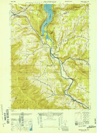
1946 Map of Prattsville
USGS Topo · Published 1946About this map
The Schoharie Reservoir dominates this mid-century landscape, illustrating the critical hydrological infrastructure serving the region. To the west, Grand Gorge sits at the junction of the Bear Kill, while Prattsville serves as a central hub further south along the Schoharie Creek. This era shows a community defined by its rural heritage, with a high concentration of family and local burial grounds like Fairlawn Cem, Huggins Cem, and Rappleyea Cem. The terrain is marked by significant elevations including Bearpen Mtn and Roundtop, while the Van Winkle Trail follows the winding path of Batavia Kill. Educational sites such as School No 1 and Little West Kill School are visible, alongside industrial markers like the Aqueduct and Gaging Sta, reflecting the management of the water system within the Catskill State Park boundaries.
Find a feature on this map
50 named features on this map. Tap any name to fly to it.
Don’t see what you’re looking for? This feature index may not catch every label — zoom into the map to look around manually.
Map Details
Editions of this 1946 Prattsville Map
This is the sole edition of this map. No revisions or reprints were ever made.
Other maps of this area

1900 · Phoenicia
USGS Topo · 1:62,500

1901 · Margaretville
USGS Topo · 1:62,500

1901 · Gilboa
USGS Topo · 1:62,500

1903 · Gilboa
USGS Topo · 1:62,500

1903 · Phoenicia
USGS Topo · 1:62,500

1904 · Hobart
USGS Topo · 1:62,500

1904 · Margaretville
USGS Topo · 1:62,500

1945 · West Kill
USGS Topo · 1:24,000

1945 · Gilboa
USGS Topo · 1:24,000

1945 · Fleischmanns
USGS Topo · 1:24,000