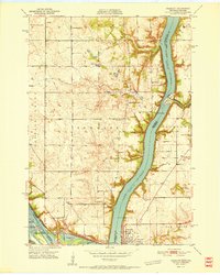
1951 Map of Prescott
USGS Topo · Published 1951About this map
Lake St Croix dominates this 1951 survey, marking the convergence of the Mississippi River and its major tributaries at the border of Minnesota and Wisconsin. The river economy is evident through the massive infrastructure at Hastings Lock & Dam and the strategically placed Elevator Bay. On the Minnesota side, the landscape is dotted with rural institutions such as Eden Grove Sch and Pennington Sch, while the settlement of Point Douglas sits at the very tip of the peninsula where the waters meet.
Find a feature on this map
38 named features on this map. Tap any name to fly to it.
Don’t see what you’re looking for? This feature index may not catch every label — zoom into the map to look around manually.
Map Details
Editions of this 1951 Prescott Map
4 editions found

Other maps of this area

1944 · Red Wing
USGS Topo · 1:62,500

1946 · Hudson
USGS Topo · 1:62,500

1946 · River Falls
USGS Topo · 1:62,500

1949 · River Falls
USGS Topo · 1:62,500

1949 · Hudson
USGS Topo · 1:62,500

1949 · Lake Elmo
USGS Topo · 1:24,000

1949 · Hudson
USGS Topo · 1:24,000

1950 · Lake Elmo
USGS Topo · 1:24,000

1950 · Hudson
USGS Topo · 1:24,000

1950 · St Paul Park
USGS Topo · 1:24,000