1993 Map of Presidio
USGS Topo · Published 1993About this map
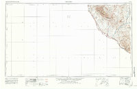
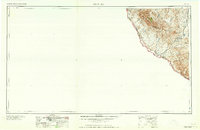
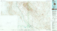
The Rio Grande snakes through a desert valley where the border between the United States and Mexico is defined by the river's winding course. This 1993 edition documents the international landscape between Presidio and Ojinaga, a region shaped by high desert peaks and seasonal watercourses. To the north, the massive Chinati Mountains dominate the terrain, providing a backdrop for the historic mining district near Shafter. Evidence of the area's mineral history is visible through the Shafter Mine and the San Antonio Mine, which are situated along the eastern slopes.
Find a feature on this map
40 named features on this map. Tap any name to fly to it.
Don’t see what you’re looking for? This feature index may not catch every label — zoom into the map to look around manually.
Map Details
Editions of this 1993 Presidio Map
2 editions found
Historical Maps of Presidio Through Time
4 maps found