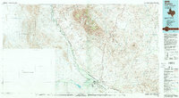
1993 Map of Presidio
USGS Topo · Published 1993About this map
The Rio Grande snakes through the center of this borderlands study, defining the international boundary between Texas and Mexico. On the northern bank, the settlement of Presidio serves as a primary hub, mirrored by Ojinaga to the south. The arid landscape is dominated by the massive Chinati Mountains and Cienega Mountains, where the local mining history is clearly etched into the terrain. Industrial remnants include the Chinati Mine, San Antonio Mine, and Sullivan Mine, concentrated near the settlement of Shafter. Transport routes like Highway 67 and Highway 170 connect these isolated outposts, while the Presidio Lely International Airport provides a modern link to the broader region. The map captures a complex network of ephemeral drainages such as Cibolo Creek, Alamito Creek, and Wilson Arroyo, illustrating how water shaped the cattle ranching and mineral extraction patterns of this high desert environment.
Find a feature on this map
64 named features on this map. Tap any name to fly to it.
Don’t see what you’re looking for? This feature index may not catch every label — zoom into the map to look around manually.
Map Details
Editions of this 1993 Presidio Map
2 editions found
Other maps of this area

1895 · Marfa
USGS Topo · 1:125,000

1895 · Alpine
USGS Topo · 1:125,000

1896 · Ruidosa
USGS Topo · 1:125,000

1896 · Polvo
USGS Topo · 1:125,000

1896 · San Carlos
USGS Topo · 1:125,000

1896 · Shafter
USGS Topo · 1:125,000

1903 · Terlingua
USGS Topo · 1:125,000

1904 · Terlingua
USGS Topo · 1:125,000

1917 · Tascotal Mesa
USGS Topo · 1:62,500

1918 · Jordan Gap
USGS Topo · 1:62,500