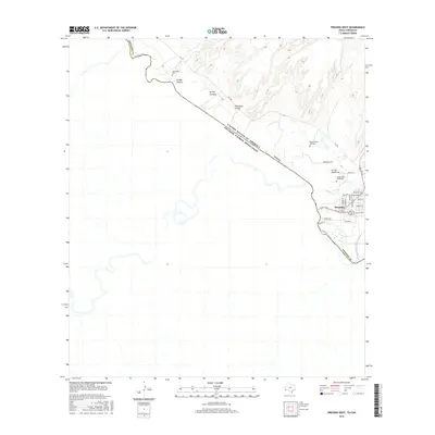
2016 Map of Presidio West
USGS Topo · Published 2016About this map
Presidio occupies the eastern edge of this borderland survey, where the international boundary follows the winding course of the Rio Grande. The landscape is defined by the sharp transition between the river valley and the arid terrain to the north, dissected by seasonal drainages such as Arroyo Chillon, Arroyo Cnangas, and Rodriguez Arroyo. Several small family or community burial sites, including Haciendita Cem, Campo Santo Rodriguez, and Campo Santo Hernandez, are situated along the terrace above the floodplain, offering significant points of interest for genealogical research in this part of Presidio County. The local road network centers on FM 170, branching into residential streets like O'Reilly St and Louvain Blvd. The confluence of Cibolo Creek with the main river marks a primary geographic feature of the basin, anchoring the settlement of Presidio within its riparian environment.
Find a feature on this map
24 named features on this map. Tap any name to fly to it.
Don’t see what you’re looking for? This feature index may not catch every label — zoom into the map to look around manually.
Map Details
Editions of this 2016 Presidio West Map
This is the sole edition of this map. No revisions or reprints were ever made.
Other maps of this area

1896 · Ruidosa
USGS Topo · 1:125,000

1896 · Polvo
USGS Topo · 1:125,000

1896 · Shafter
USGS Topo · 1:125,000

1959 · Presidio
USGS Topo · 1:250,000

1965 · Presidio
USGS Topo · 1:250,000

1978 · La Boquilla
USGS Topo · 1:24,000
1979 · Indio
USGS Topo · 1:24,000
1979 · Presidio West
USGS Topo · 1:24,000

1979 · Presidio East
USGS Topo · 1:24,000

1980 · Arroyo Melado
USGS Topo · 1:24,000