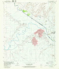
1979 Map of Presidio West
USGS Topo · Published 1979About this map
The international boundary between Texas and Chihuahua is defined by the winding course of the Rio Grande Rio Bravo, where the confluence with the Conchos River marks a significant geographic junction. This 1970s survey details the binational urban centers of Presidio and the larger Ojinaga, connected by a Toll Bridge and a formal Port of Entry. The Mexican side of the river features the planned residential grids of Porfirio Ornelas and numerous agrarian settlements like San Francisco and El Tecolote.
Find a feature on this map
47 named features on this map. Tap any name to fly to it.
Don’t see what you’re looking for? This feature index may not catch every label — zoom into the map to look around manually.
Map Details
Editions of this 1979 Presidio West Map
This is the sole edition of this map. No revisions or reprints were ever made.
Other maps of this area

1896 · Ruidosa
USGS Topo · 1:125,000

1896 · Polvo
USGS Topo · 1:125,000

1896 · Shafter
USGS Topo · 1:125,000

1959 · Presidio
USGS Topo · 1:250,000

1965 · Presidio
USGS Topo · 1:250,000

1978 · La Boquilla
USGS Topo · 1:24,000
1979 · Indio
USGS Topo · 1:24,000

1979 · Presidio East
USGS Topo · 1:24,000

1980 · Arroyo Melado
USGS Topo · 1:24,000
1985 · Presidio
USGS Topo · 1:100,000