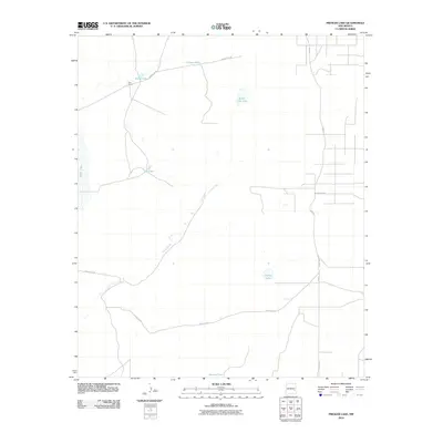
2010 Map of Presler Lake
USGS Topo · Published 2010About this map
East Camp serves as the primary named settlement in this arid section of Chaves County, centered around a network of livestock tanks and seasonal water bodies. The geography is defined by subtle depressions and drainage systems, most notably the winding course of Long Arroyo which cuts diagonally across the landscape. The reliance on water management is evident through numerous man-made features like Cooper Tank, Broke Tank, and Duncan Tank, which support ranching in a region where natural basins such as Presler Lake and Red Lake often remain dry. A sparse grid of rural roads, including County Rd-50 and the aptly named Bad Rd, provides the only access through these expansive grazing lands.
Find a feature on this map
12 named features on this map. Tap any name to fly to it.
Don’t see what you’re looking for? This feature index may not catch every label — zoom into the map to look around manually.
Map Details
Editions of this 2010 Presler Lake Map
This is the sole edition of this map. No revisions or reprints were ever made.
Other maps of this area

1949 · Sardine Mountain
USGS Topo · 1:24,000

1954 · Brownfield
USGS Topo · 1:250,000

1955 · Roswell
USGS Topo · 1:250,000

1958 · Brownfield
USGS Topo · 1:250,000

1958 · Roswell
USGS Topo · 1:250,000

1962 · Roswell
USGS Topo · 1:250,000

1962 · Brownfield
USGS Topo · 1:250,000

1967 · Elkins
USGS Topo · 1:24,000
1967 · Sardine Lake
USGS Topo · 1:24,000
1973 · Oasis
USGS Topo · 1:24,000