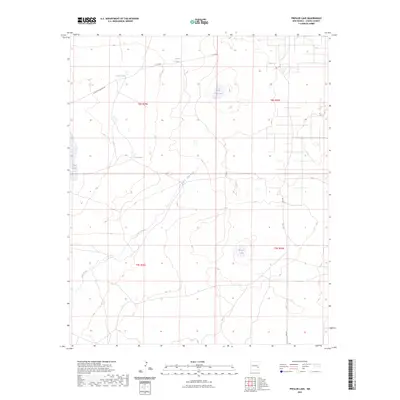
2023 Map of Presler Lake
USGS Topo · Published 2023About this map
Presler Lake and the drainage of Long Arroyo dominate this Chaves County landscape, where water management is the primary marker of human presence. The terrain is defined by a network of catchments and natural depressions, including Broke Tank Lake, Lost Lake, and Red Lake. This modern survey illustrates how ranching infrastructure utilizes the natural topography, with livestock tanks such as Broke Tank and Cooper Tank situated at strategic collection points. Transportation is limited to a sparse grid of rural routes like White Lake Ranch Rd and Cato Rd, reflecting the low-density, agricultural character of this region. The map provides a clear record of the Public Land Survey System divisions, specifically through townships T8S and T9S, which organize the vast open tracts of this high-desert environment.
Find a feature on this map
15 named features on this map. Tap any name to fly to it.
Don’t see what you’re looking for? This feature index may not catch every label — zoom into the map to look around manually.
Map Details
Editions of this 2023 Presler Lake Map
This is the sole edition of this map. No revisions or reprints were ever made.
Other maps of this area

1949 · Sardine Mountain
USGS Topo · 1:24,000

1954 · Brownfield
USGS Topo · 1:250,000

1955 · Roswell
USGS Topo · 1:250,000

1958 · Brownfield
USGS Topo · 1:250,000

1958 · Roswell
USGS Topo · 1:250,000

1962 · Roswell
USGS Topo · 1:250,000

1962 · Brownfield
USGS Topo · 1:250,000

1967 · Elkins
USGS Topo · 1:24,000
1967 · Sardine Lake
USGS Topo · 1:24,000
1973 · Oasis
USGS Topo · 1:24,000